PWPro finds out what it takes to build and maintain the best driving roads in Australia.
Northern Territory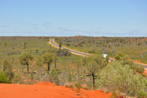 Lasseter Highway
Managed by: Northern Territory Department of Infrastructure
Managed by: Northern Territory
Department of Infrastructure
Used by tourists, miners and cattle farmers alike; the Lasseter Highway has its origins in the 1930s when a local station owner built a track to Uluru.
A professional survey was conducted in the 1970s, which identified the route that would become known as the Lasseter Highway. The road was sealed in the early 1980s as part of a project to promote tourism to Uluru and the Olgas. Today the Lasseter Highway connects Winton and Longreach in Queensland with Leonora and Kalgoorlie in Western Australia.
“The Lasseter was built to the old 20 foot (6m) standard,” says David McHugh, Chief Executive at the Northern Territory Department of Infrastructure. “Upgrading to the current standard of 8m seal on 10m carriageway has been carried out [on] various sections as funds [have become] available.”
Bitumen resealing of the surface takes place every 12 to 15 years, regravelling of shoulders every 12 to 15 years and line marking refreshment every one to two years with various sections undertaken in most years.
Scarcity and quality of water is one the main challenges for the teams who maintain the road as local bores contain high salt levels unsuitable for bitumen, so water often has to be trucked in.
Western Australia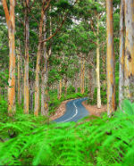
Caves Road
Managed by: Main Roads Western Australia
Caves Road travels through national park land from Busselton in the north, down the coast to Augusta.
The 110km popular tourist route is dotted with wineries and further south it winds through cave country – some caves even pass under the road.
Main Roads Western Australia’s maintenance workers are often faced with the dilemma of sacrificing bush for road due to the route’s narrow seal.
“The trees are typically a couple of metres off the edge of the seal,” says Gerry Zoetelief, Acting Director South West Operations, Main Roads Western Australia. “We do our best to maintain the shoulders as best we can without disturbing the trees as far as practical.”
Drainage is also an issue. Small drains are sometimes required to deal with large volumes of water and occasionally road shoulders get scoured out.
“Trying to get that shoulder maintenance done is sometimes difficult, but the guys learn how to work in those constraints,” says Zoetelief.
Over the past couple of years, MRWA has been undertaking maintenance work on various parts of the road. This has included the widening of shoulders between Dunsborough and Yallingup and the building of a bypass in Dunsborough. There are also plans to improve an intersection in Yallingup.
Victoria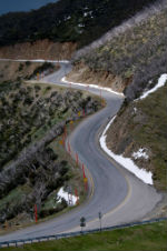
Great Alpine Road
Managed by: VicRoads
Tourist and freight drivers share the Great Alpine Road as it connects the North East with Gippsland. Drivers can skim along the mountain ranges enjoying the views as they wind their way through provincial towns such as Wangaratta, Bright, Omeo and Bairnsdale.
“Regular users of this road know that it operates as a two lane road that winds its way through mountains, valleys and forests for just over 300km,” says Bryan Sherritt, VicRoads Regional Director North Eastern.
“Ensuring the road is well maintained and operating safely can present some challenges, which are largely related to the varying climatic conditions.”
The road around Mount Hothan, which rises to an altitude of around 1800m and can regularly be blanketed with snow during winter months, often requires regular cleaning to keep it open. In summer, bush fires can also be a problem.
VicRoads has established a collaborative maintenance agreement with the North Eastern Maintenance Alliance (NEMA). The organisation’s work includes regularly inspecting the whole length of the road to ensure its safe condition.
Over the past 24 months, VicRoads has resealed or rehabilitated many kilometres of road to make it smoother and more water resistant.
New South Wales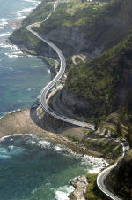
Lawrence Hargrave Drive/Sea Cliff Bridge
Managed by: Roads and Maritime Services
Lawrence Hargrave Drive winds its way along the coast from Stanwell Park in NSW to Thirroul. The road joins the Sea Cliff Bridge between Coalcliff and Clifton.
Darting out over the ocean, the bridge has featured in ads for brands ranging from Holden to Ferrari.
The Sea Cliff Bridge was built to replace a section of Lawrence Hargrave Drive that was permanently closed in August 2003, due to regular rock falls.
The bridge was officially opened on 11 December 2005 and is one of only seven off-shore bridges parallel to the coast, in the world. It has a footpath and cycleway and has become a popular tourist attraction.
In 2013 an average of 4100 vehicles used the road every day. RMS staff inspect the bridge every two years using a mobile platform and monitors slopes and groundwater levels.
Steps were taken during the bridge’s construction to ensure workers’ safety, for instance rock bolts were drilled into the cliffs to stabilise them and access tracks were built for workers.
“The Illawarra coal seam is at sea level along this section of the coastline,” says a Roads and Maritime Services spokesperson. “This results in significant erosion from the sea and unstable cliff lines for up to 500 metres above.”