What: MacKenzie Falls Trail
Who: Parks Victoria and Hansen Partnership
Why: The existing link between MacKenzie Falls and Zumsteins Picnic Ground was destroyed when the Grampians flooded in 2011
How much: The construction budget was $180,000
When flooding in 2011 washed away a footbridge in Victoria’s Grampians National Park, Parks Victoria could have simply rebuilt it. Instead, they chose to provide visitors with a far more intimate journey through the stunning MacKenzie Falls Gorge.
The Hansen Partnership-designed project – which connects MacKenzie Falls to historically-significant Zumsteins Picnic Ground – has also withstood a major bushfire with minimal damage, testament to the careful choice of steel as the main building material, Director Steve Schutt says.
“Thorough analysis demonstrated steel was more suitable for the infrastructure elements, as its strength and durability would withstand flooding and bushfire events,” he explains. “The frequency of these events and the need to stand the test of time outweighed the lifecycle management benefits of timber.”
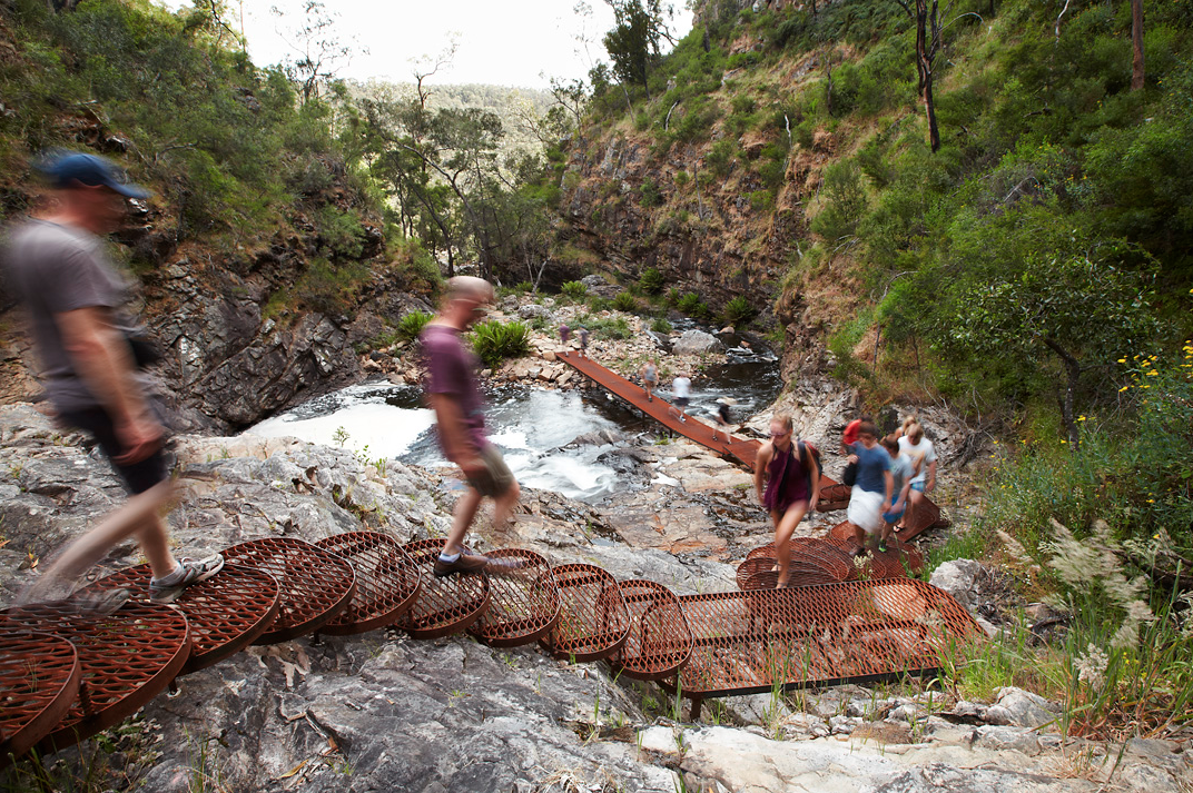
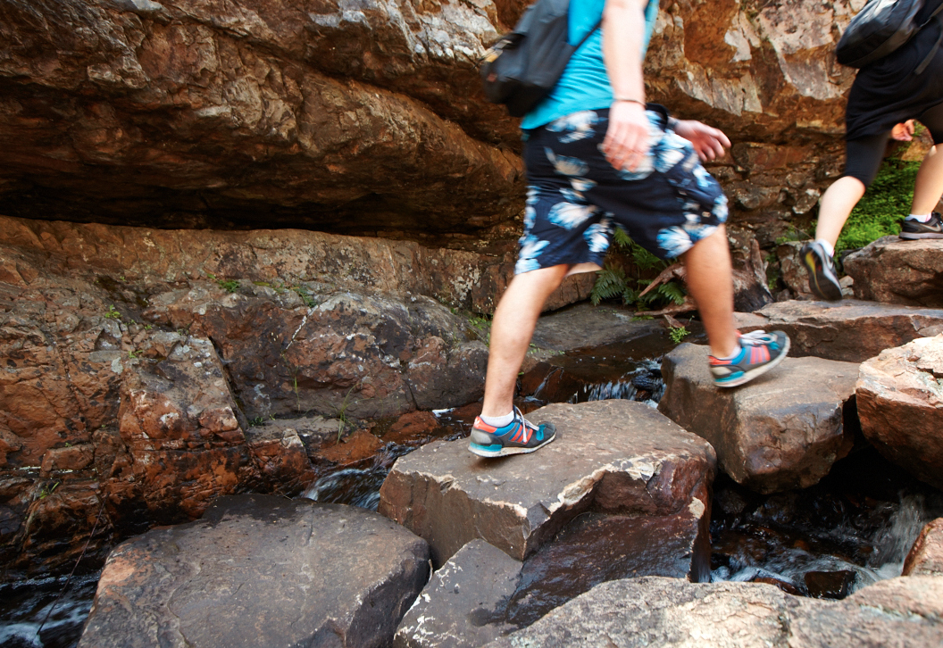
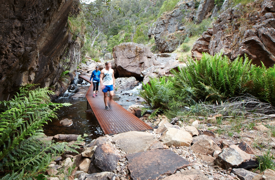
The new trail combines sections of expanded mesh that bridge slower-moving parts of the river, with pieces of sandstone mined from the site that were broken up and rearranged to form steps and stepping stones on higher ground.
Instead of crossing the river below the falls and leading up to the ridge-line as it did before, the path takes visitors through the base of the valley, as close to the river as possible. The lower bridge crossing was strategically located to the lower, flatter area of the gorge. Schutt says this not only provides the visitor with views to the lower falls, but will also protect the structural integrity of the bridge when the area inevitably floods again – the project brief’s key requirement.
“The previous trail alignment led visitors up a ridge line, which deprived them of views and an intimate experience of the lower falls,” Schutt says. “The walkway was located over slower moving water to negate the need for handrails in order to conform to the Australian Standards in trail design, a method used to restrict the impact of the manmade features in the environment.”
The previous blue powder-coated footbridge was installed in the 1980s, and was visually obtrusive both in size and colour. Schutt says care was taken to ensure the new project melded into the landscape.
“It was purposefully designed to omit handrails as a means of reducing surface area, which would have gathered debris during future floods and reduced structural integrity,” he explains. “Mild steel was chosen over galvanised steel to due to lower environmental impacts over the materials life cycle. No concrete was used in the construction of the trail due to the negative effects it would have had on the environment and the strict environmental guidelines of the Grampians Water Authority.”
Located three and a half hours from Melbourne and a further half an hour on foot across steep terrain, Schutt says actually accessing the site proved challenging.
“Quality aerial photography and survey information was unavailable; therefore gathering information on site was crucial,” he explains. “The remoteness and lack of base data created the need for innovative measures of data collection."
The site dictated the use of old-school techniques for data collection, analysis and construction.
“Extended site visits were required to immerse the designers in the landscape setting in order to gain a full appreciation and understanding of the study area,” Schutt says. “Every rock face, landscape element and natural feature were inspected and documented through sketch design and on-site mapping using pen and paper.”
The landscape team used alternate techniques to document and gather information through on-site visual mapping and photo assessment, to deliver a site-specific report. More conventional digital means – photo-mapping and video footage – were also used.
Given the site’s inaccessibility, manpower was the only construction technique available. Large boulders and stones were sourced from site and positioned by hand. The steel was sourced and fabricated by Ricksteel Fabrications, located in the nearby town of Ararat. The walkways, steps and additional gravel was flown in via helicopter and assembled on site using generators and welders.
The project’s concept design was 10 months in the making, with detailed design and construction taking a further 15 months.
Since its completion in 2014, the MacKenzie Falls Trail project has snagged a swag of accolades, including Best in Category Award for Architectural Design at the 2015 Premier’s Design Awards, Finalist, Landscape Category, WAN Awards 2015 and Best in Category Award for Architectural Design - Urban Design & Public Spaces, Good Design Awards, 2015.
Photos: Courtesy of Andrew Lloyd.