The grim reality of rising sea levels has prompted councils in New Zealand to look at how they manage their development plans and coastal assets.
At least 9000 homes around New Zealand are situated less than 50cm above the spring high-tide mark, according to the recently released Preparing New Zealand for rising seas: certainty and uncertainty.
The sea level around New Zealand is projected to rise by about 30cm between 2015 and 2065, according to the report.
Rising sea levels will lead to flooding on low-lying land near the coast, erosion of many beaches and “soft” cliffs, and higher and possibly saltier coastal groundwater, the report predicts.
Parliamentary Commissioner for the Environment Dr Jan Wright launched the document, and emphasised the need for councils to consider future sea level rise when approving greenfield developments.
“There are aspects of planning for sea level rise that should be done with some urgency,” she wrote.
“One is concerned with the granting of consents for greenfields development. New suburbs and the expensive infrastructure they require should be viewed as long-term investments. We now see building new suburbs on land prone to liquefaction in much of the country as foolish. We should see allowing new subdivisions on vulnerable coastal land as equally foolish.”
New Zealand’s largest city is already taking steps to mitigate the effect rising sea levels will have on its residents and infrastructure. 
Auckland Council Chief Engineer, Sarah Sinclair says a new development planning document, the Auckland Unitary Plan, is being formulated as a result of the region’s 2010 amalgamations.
Although Auckland is yet to feel the full effects of rising sea levels, Sinclair says the council is taking a proactive approach in the plan.
“There was an awful lot of background work that went into that to develop an idea of how rising seas would affect us,” Sinclair says.
“That document was put out to public consultation in 2013, that included a great deal of work on things like where a 1m sea level rise might affect coastal flooding, and for areas which have been identified for future development, where a 2m rise might affect coastal flooding, so that people can take it into consideration when planning development and planning mitigation.
"We used the same specialists as the Commissioner did for her report.
“The maps that we developed are in the public domain.
“The Unitary Plan is proposed at the moment, and it’s going through the democratic process where we’ve got feedback from the members of the public on a variety of things inside the plan. We’re going through the Hearings process at present.
“The final version is not yet decided, but the Plan does include managing for climate change in terms of policy and in terms of natural hazards such as rising seas.”
The inexorable rise in sea levels is also dictating how the council manages its coastal assets, Sinclair says.
“We’re doing a lot of work as a council around regional managing of our assets on the coast,” she explains.
“There is direct action where we need there to be direct action – as asset managers, we will continue doing renewals, repairs and new capital investments.
“We need to make sure we have, in our existing design toolkit, the ability to design infrastructure for the whole of its life.”
Sinclair, who is on the IPWEA NZ Board of Directors, says Auckland is developing strategies to protect and manage its coastline. 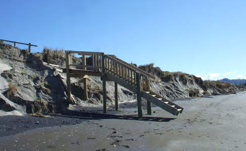
“We’re very much looking at the concept of coastal compartment management plans – looking at a larger stretch of coastline, and developing management plans across that stretch of coastline, so that individual elements such as seawalls can be planned to work coherently in a wider coastal system,” she explains.
“The way we are proposing to use these is innovative within NZ.
“Coastal processes are systems – a coastal process will work on potentially quite a large area, because the whole area works as a coastal system.
“We’re saying, ‘manage the system as well as the asset. Think about the whole lot and then look at the elements that make up the system, so that your asset element works within the system, rather than changing it adversely’. It also means we can prioritise within the system what needs doing.”
Sinclair believes it is important councils across the country, in light of an impending rise in sea levels, collaborate and share knowledge.
“One of the things I’m very much driving with IPWEA is that cross-council collaboration,” she says. “One of the benefits of IPWEA is to be a vehicle by which councils can communicate with each other and share good ideas.”
“Not everything works in every situation and, quite often there will be one or two engineering options for one area, that will be completely not the right options for another area.
“Part of the benefit of looking to this more regional approach, is it does really raise that as a standard flag, that we are looking for best technical outcome, and within that, we’re very happy to engage with our communities to make sure that we come up with solutions that are acceptable to them.”
Image captions
Image 1: In February 2015 a king tide caused minor flooding on boardwalks in Howick, Auckland. (Source: Craig Thompson/Preparing New Zealand for rising seas: certainty and uncertainty.)
Image 2: Waihi Beach is subject to episodes of erosion when storms gouge sand out of the dunes. (Source: Western Bay of Plenty District Council/ Preparing New Zealand for rising seas: certainty and uncertainty.)